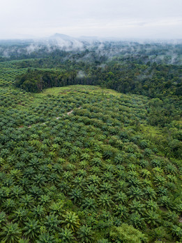
Southeast Asia is undergoing rapid environmental change due to population growth, urbanization and economic development. These drivers are exerting immense land-use change pressures. The conversion of land from forest to agriculture and from agricultural areas to residential and urban uses is undermining vital ecosystem services that, among other factors, protect human settlements from flooding and other extreme events.
Remote sensing technology is critical in this region for ensuring robust monitoring and research on the impacts of land-cover and land-use change. This in turn helps to support public awareness and decision making that affect forestry and industry. The widespread conversion of forests to oil palm cultivation is a key case in point.
Objectives and priorities
The SEARRIN network promotes collaboration and capacity building (through annual meetings and training events) that enhance the use of remote sensing data for LCLUC studies.
Recent meetings include an International Regional Science Meeting held in Malaysia in 2019, which brought together 170 participants from 16 countries, explored the availability, potential, and limitations of different data sources and methodologies for research and monitoring LCLUC in the region. A 3-day hands-on training for 85 young researchers followed the meeting.
Another 3-day training event was offered in 2019 in Thailand to 90 scientists, mostly earlycareer researchers from South and Southeast Asia. The event was organized by the space agencies of the United States (NASA), Japan (JAXA), Thailand (GISTDA) and India (ISRO).
“Participating in the network provides a great opportunity for increased visibility and reputation to UTM – Universiti Teknologi Malaysia. During a recent network meeting, researchers from Malaysia presented outcomes in the field of forestry, atmosphere, urban and coastal areas.
Personally, thanks to the network I have been able to collaborate with researchers from the region and publish in special issue journals and book chapters. I have also been invited to be a trainer in one of the capacity building events hosted by the NASA LCLUC program in Phuket in 2019 and to present perspectives from Southeast Asia in a meeting in Washington, DC.” – Kasturi Devi Kanniah, Head of TropicalMap research group, UTM – Universiti Teknologi Malaysia


