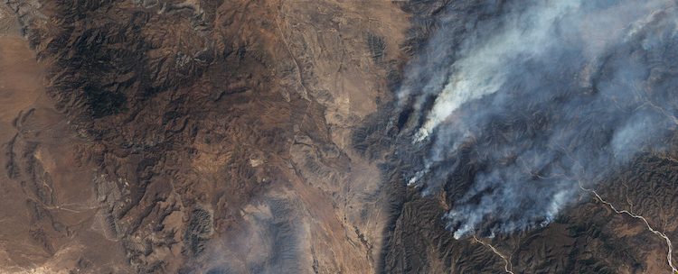
Over 20,000 fires rage across Central America every year, affecting over 670,000 hectares of land (approximately 4.5 times the area of Mexico City) and contributing to regional and global challenges including deforestation, agricultural contamination, and climate change. In 2019, hot and dry conditions fueled an intense fire season in Mexico which caused hazardous air conditions in many parts of the country.
“Early warning can provide essential information to decision makers to both fight and control fires before they become more severe, as well as to civil protection agencies whose objective is to reduce the health impacts of forest fire smoke on the population” shares Lilia de Lourdes Manzo Delgado, a former GOFC-GOLD Data Initiative fellow and Academic Technician at the National Autonomous University of Mexico (UNAM).
Since 2017 Lilia has been coordinating a project to develop a National Early Warning System for Wildland Fires, which has been launched in March of this year. Lilia and her students, along with colleagues from INPE Brazil, developed an algorithm to detect hot spots for Mexico and made the system operational. “While the final tool is based on Sentinel-2, my experience with Landsat and the concepts reviewed during the DI training have been very important all along this project,” adds Lilia.
She also cites the Data Initiative as instrumental in improving her production and academic participation at the Institute of Geography at UNAM, including research projects, teaching, and publishing scientific articles. “The DI training helped me to better understand the importance of using satellite imagery and helped improve my skills in using remote sensing techniques, geographic information systems and statistical analysis focused on the change of vegetation and land use,” says Lilia. In fact, after the Data Initiative, Lilia had the opportunity to propose and teach a new class on “Vegetation and Land Use” for the Geography postgraduate program at UNAM. The structure and content of the class, which she has taught every year since 2014, includes many topics and activities that were covered in the training program at USGS-EROS and Boston University.
In her closing reflections about the Data Initiative, Lilia shared: “My favorite memory of the Data Initiative was when Professor Curtis Woodcock of Boston University invited us to reflect on what we would each do, back home, after the training. We all concluded how crucial it would be to share the information and knowledge we had gained from the Data Initiative with our colleagues, students and networks back home. This is what I did, after the DI training, and I am still doing today through my various projects.”