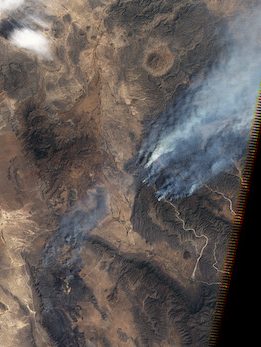
Satellite data is critical to monitoring and assessing the widespread fires that regularly occur in Latin America’s forests, grasslands and savanna regions. While more and more data is available to scientists, there is an increasing need to make this data and satellite products accessible to the end users, ranging from firefighters to policymakers.
Objectives and priorities
The RedLaTif network coordinates activities related to the observation and management of fires in Latin America, which includes assessing and validating global satellite fire products, promoting use of remote sensing data, and bridging the gap between end users and space agencies. The network produces joint scientific publications, participates in fire-related congresses, and contributes to the GOFC-GOLD fire implementation team agenda.
Accomplishments
The network has greatly helped members access satellite fire products and apply them to real-life problems. Thanks to the network, scientists and practitioners from the region have been able to benefit from the advanced systems, technology and knowledge of national programs such as Brazil’s INPE and Mexico’s CONABIO.
Among the many joint activities and collaborations, a few notable examples include:
• A milestone paper in 2008, “Global burned-land estimation in Latin America using MODIS composite data”, the result of the collaboration of experts from the entire region. The paper presented results from a GOFC-GOLD project through which monthly burned-land maps of the entire region, from Mexico to Patagonia, were obtained.
• The SERENA project, funded by CYTED, which provided the opportunity to receive additional funds for members to meet and coordinate the development and transfer of technologies. For example, Gerardo López from CONABIO visited Argentina’s Instituto de Clima y Agua (INTA) and installed a MODIS hotspot collection system, which is now working operationally.
• A Burned Area Detection Workshop in 2015 organized by INPE – Instituto Nacional de Pesquisas Espaciais, in São José dos Campos, Brazil. The workshop had a double objective: to gather participants from across the region to conduct a practical mapping of burned areas (with each participant working on satellite images of their own country), and to host a satellite validation experiment with controlled burning on ground. Both activities were very useful to enhance participant’s abilities in burned area detection and validation techniques.
• More recently, the promotion of webinars as a new way of communication and dissemination of firerelated activities and research. Five webinars have been held since November 2019, featuring network members and invited experts. Topics covered included cutting edge satellite products and services; advances in the development and implementation of methodological instruments for the analysis of fires through remote sensing; and opportunities and challenges for monitoring forest degradation.
“The RedLaTif network has been fundamental in facilitating collaboration and information sharing on earth observations in the region. Thanks to the network, advanced programs such as Brazil’s INPE and Mexico’s CONABIO have shared their knowledge and technology with the other countries, and institutions across the region have been able to share data with end users, to improve fire management and solve real-life issues related to fire.
As an expanding network, we are focused on the integration of new participants with the hope to be a network with expert representation from all Latinoamerican countries. This will lead to more interactions and benefit those countries with fewer capabilities in remote sensing tools.” – Nicolás Alejandro Mari, Investigador – extensionista, Instituto Nacional de Tecnología Agropecuaria (INTA), Argentina


